Footpaths in Moorlinch
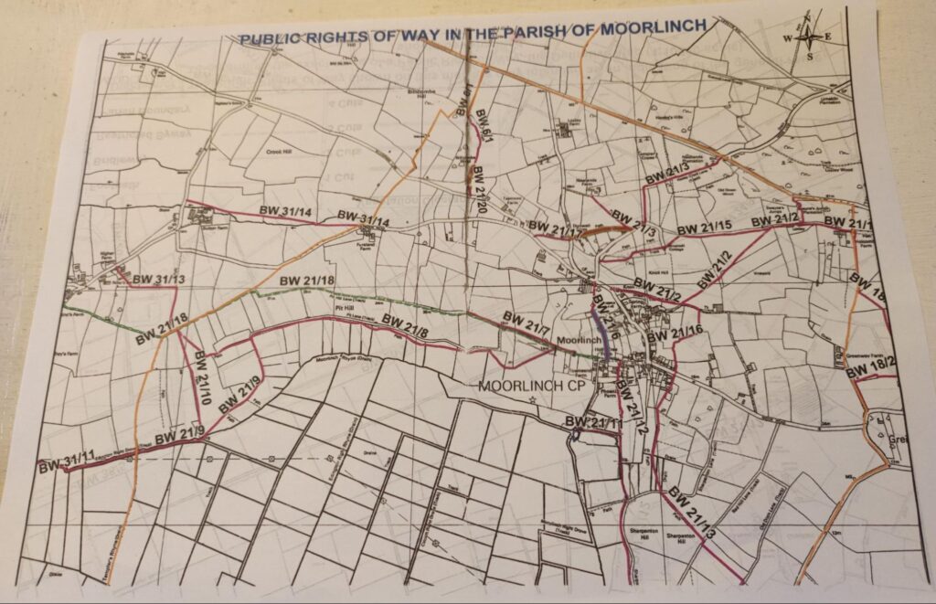
Britain is very fortunate in having a fine network of footpaths allowing public access to a wide variety of land. Moorlinch is no exception. It is criss-crossed with paths enabling walkers to enjoy the openness and skyscapes of the Levels or the views and woods of the Polden Hills. With very little heavy traffic to navigate, walkers can connect more directly with the natural world via the flora and fauna of the local landscape and the occasional farm animal.
Walking proved a godsend in the lockdowns of the pandemic for many stranded at home; dogs were walked (sometimes to the point of exhaustion!), children asked to go out and neighbours got to know each other as well as their neighbourhood. Post lockdown, judging by the numbers I see when out and about, people have continued to walk having built it into their daily exercise and well-being routines. There is much to be said for being out of doors experiencing the weather and noting the changing seasons and agricultural practices. The long-distance trail of the Samaritan’s Way linking Bristol to Lynton comes through the village and I know that several locals have completed it.
How do you find the local footpaths? The cheapest and easiest way is to go online and access the Explore Somerset map. Just enter https://roam.somerset.gov.uk/roam/map into your browser and Moorlinch into the search box and the footpaths will come up. Alternatively invest in the Ordnance Survey maps, although Moorlinch is annoyingly on the cusp of two maps OS 140 and OS 141 and both are needed. However, map reading is a great skill to learn and the OS maps provide a range of interesting detail that will come in helpful on your rambles.
What do the different coloured arrows denote on a footpath sign? There are four types of public right of way, the yellow arrow denotes a right of way for walkers and wheelchair users and points the way. The blue arrow denotes a Public Bridleway that may be used by horse rider and cyclists as well as walkers and wheelchair users. The purple arrow denotes a Restricted Byway. These provide a right of access for walkers, wheelchair users, horse riders, cyclists and users of non-mechanically propelled vehicles such as horse drawn carriages i.e. no motorised vehicles. The red arrow denotes a Byway Open To All Traffic which means that it is a right of way for all including motorised vehicles. As well as these metal discs there are also wooden signposts indicating a public path and the direction to be taken. There are also items called ‘furniture’ which include stiles, gates and bridges. Sometimes these get broken or overgrown with vegetation and can be tricky to navigate. Feel free to carry out light clearance such as cutting back the vegetation from around gates, stiles and signposts but do contact me or use the issues box on the Explore Somerset map to report damage to furniture. Once a problem is known it will be resolved, and removing obstructions or improving a route encourages people to explore with confidence.
There are some rules to be aware of when walking on a public footpath. These are found in the Country Code and are really just common courtesy – take your litter home, pick up dog poo, leave property as you found it, shut gates behind you. Because we live in close proximity to a Site of Special Scientific Interest (SSSI) which provides protection within a conservation area to ground nesting birds, dog owners should keep their dog on a lead during the nesting period to avoid accidentally damaging a nest, trampling fledglings or scaring off the parent birds.
Landowners and Farmers who have public footpaths crossing their land have responsibilities too. Primarily it is their responsibility to ensure that their land remains open and easy to use and is not obstructed. Any access furniture should be maintained to be in a safe and useable state and when ploughing or cropping land with public access, ensuring that it is reinstated to its former state within two weeks.
Public footpaths are there for all to use and enjoy. If you need further information please contact your Public Paths Officer, Carrie Skinner via the contacts page.

